
Understanding the 2027 Texas State Water Plan
What the plan measures, what its maps mean, and why landowners should pay attention before a project reaches their property.
Planning status may change. This article describes the Draft 2027 State Water Plan — Phase I, dated April 16, 2026, which is a draft, not the final adopted plan. Confirm the latest TWDB adoption, amendment, project, and map information before relying on this page.
What is the State Water Plan?
Every five years, the Texas Water Development Board (TWDB) publishes a state water plan — the state's long-range roadmap for making sure Texas has enough water through decades of growth and drought. The 2027 State Water Plan is the state's twelfth water plan and the sixth completed through the regional planning process, in which local and regional planning groups build the plan from the ground up.
The plan does not build anything by itself. It measures projected population, water demand, and existing supply; identifies where shortages could develop under drought; and compiles the water-management strategies and projects that regional groups recommend to close the gap. Inclusion in the plan matters for state financing and permitting, which is exactly why landowners should understand what inclusion does — and does not — mean.
Current status of the 2027 plan
The document this article describes is the Draft 2027 State Water Plan — Phase I, dated April 16, 2026. It is a draft. It should not be described as the final adopted plan unless TWDB confirms adoption.
Phase I and the expected Phase II amendment
Phase I was prepared on an accelerated schedule to support July 2026 commitments under the State Water Implementation Fund for Texas (SWIFT), the state's water-project financing program. TWDB intends to consider a Phase II amendment before the January 5, 2027 statutory deadline. Practically, that means the plan's contents — including project lists and figures — may still change between now and final adoption and amendment.
Texas' 16 regional water-planning areas
The state plan is built from 16 regional water plans, each produced by a regional water planning group made up of local stakeholders — cities, utilities, agriculture, industry, environmental interests, and others. The 2027 plan evaluates approximately 3,000 water-user groups across the state, sorted into six statewide water-use categories: municipal, manufacturing, steam-electric power, mining, irrigation, and livestock.
For a landowner, the regional plan is often more useful than the state plan: it names specific projects, sponsors, and locations in your part of Texas.
What is drought-of-record planning?
The plan's central question is not "is there enough water in an average year?" It is "would there be enough water if the worst recorded drought happened again?" Supplies and shortages in the plan are measured against drought-of-record conditions — the most severe drought documented for each area. That conservative yardstick is why the plan can show shortages even in regions that feel water-secure today.
Population and water-demand projections
The draft projects Texas' population to increase from approximately 34.2 million in 2030 to 52.3 million in 2080. Total annual water demand is projected to rise from approximately 17.4 million acre-feet to 18.4 million acre-feet over the same period. Demand grows more slowly than population in part because municipal use per person is projected to decline and irrigation demand shifts over time.
Existing water supplies
Existing drought-reliable water supplies are projected to decline from approximately 15.5 million acre-feet to approximately 14 million acre-feet by 2080. The decline is not evenly split: existing groundwater supplies are projected to decline approximately 19% between 2030 and 2080 — driven largely by regulated reductions in aquifer pumping and depletion — while existing surface-water supplies are projected to decline approximately 2%, largely from reservoir sedimentation.
Potential shortages
Comparing demand against existing supply under drought-of-record conditions, the draft projects potential shortages of approximately 3.6 million acre-feet in 2030, growing to 5.8 million acre-feet in 2080. Municipal water needs rise substantially over the planning period. A projected shortage is not a prediction that taps will run dry — it is the gap the recommended strategies are designed to fill.
What the $174 billion figure means
The Draft 2027 State Water Plan estimates that more than 3,000 recommended water-supply projects could require nearly $174 billion in capital investment through 2080, measured in 2023 dollars and excluding future inflation.
Read that carefully. It is a cumulative, multi-decade capital estimate across thousands of projects with many different sponsors — cities, river authorities, utilities, districts — not a single immediate state expenditure. It also does not include costs for routine replacement, maintenance, or rehabilitation of existing infrastructure, which sponsors bear separately.
Recommended water-management strategies
The plan recommends approximately 6,700 water-management strategies and more than 3,000 associated projects. A "strategy" is any measure that produces or frees up water: conservation programs, reuse, new wells, new reservoirs, desalination, pipelines, contracts, and more. TWDB identifies permitting, financing, site selection, water rights, property acquisition, and easement acquisition as possible implementation obstacles — several of which run directly through private land.
Conservation, reuse, groundwater, and surface water
Conservation strategies account for approximately 30% of recommended strategy supply in 2080; conservation and reuse together account for approximately 43%. On the supply-development side, new major reservoirs account for approximately 676,053 acre-feet per year of recommended 2080 strategy supply, other surface-water strategies account for approximately 1.88 million acre-feet per year, and surface-water development overall accounts for approximately 36% of recommended future strategy supply.
In short: the plan leans heavily on using existing water better, while still recommending substantial new surface-water infrastructure — the category most likely to involve land acquisition and easements.
What appearing in the plan does — and does not — mean
A project's appearance in the state water plan means a regional planning group recommended it and TWDB compiled it. It does not mean the project is:
- approved or permitted;
- funded or financed;
- finally sited or surveyed;
- scheduled for construction;
- authorized to acquire or condemn any particular parcel.
Projects in the plan can change size, move, stall, or never be built.
Why plan inclusion still matters
At the same time, inclusion is not meaningless. Consistency with the state and regional plans matters for TCEQ water-right permitting, and inclusion is generally a prerequisite for certain state financing, including SWIFT. A project in the plan has taken a real step along the path from idea to infrastructure. For a landowner near a mapped project, the plan is the earliest, cheapest warning system available — the right time to start following the sponsor's public meetings, not to panic.
Existing reservoirs
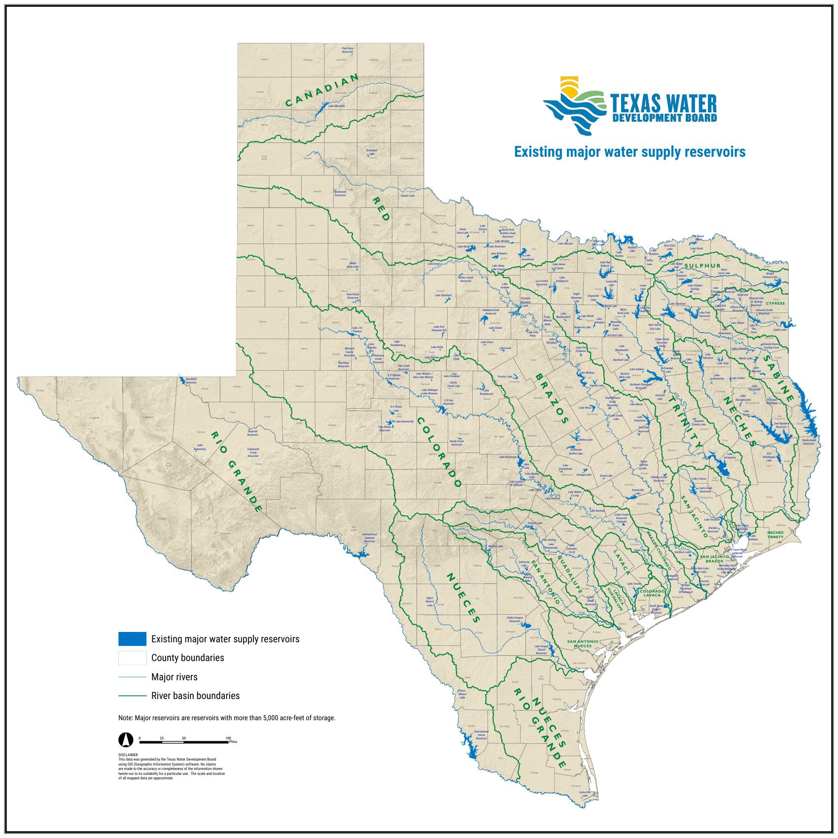
The plan's companion map of existing major water supply reservoirs shows reservoirs with more than 5,000 acre-feet of storage, together with county boundaries, major rivers, and river-basin boundaries. Mapped locations and boundaries are approximate.
Recommended new reservoirs
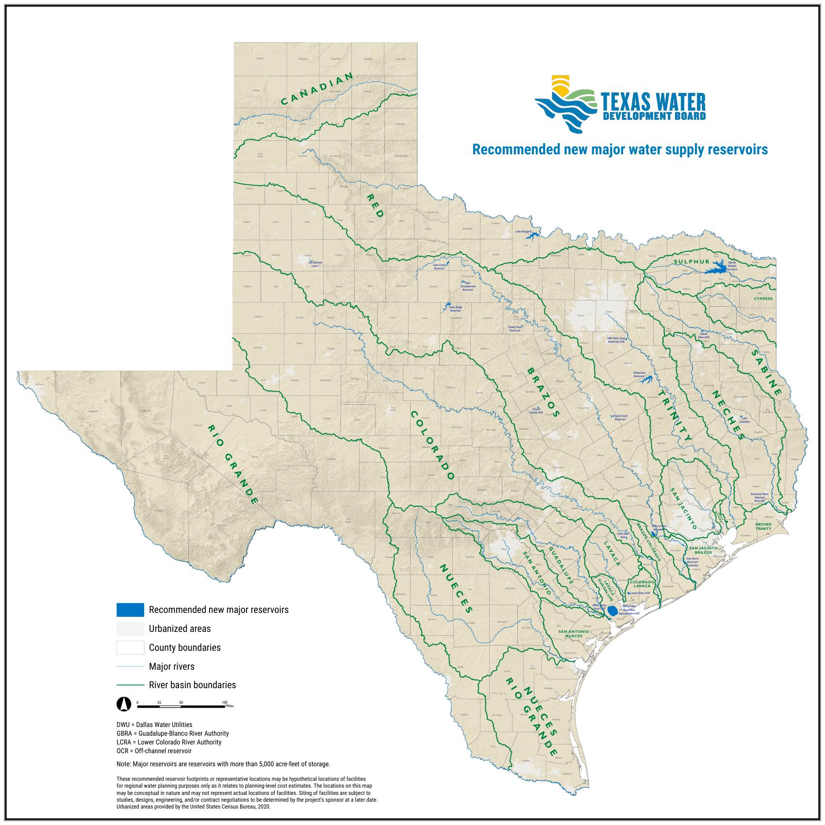
The draft's recommended-strategy list includes new major water supply reservoirs, shown on a companion TWDB planning map.
Planning map — not a final acquisition map
Inclusion does not mean that a project is fully approved, funded, permitted, or scheduled for construction. It does not establish that a particular parcel will be purchased or condemned.
What conceptual reservoir maps mean
The recommended-reservoir map carries its own note, and it deserves emphasis: recommended reservoir footprints or representative locations may be hypothetical locations for regional planning purposes only, may be conceptual in nature, and may not represent actual locations of facilities. Siting is subject to studies, design, engineering, and contract negotiations to be determined by the project's sponsor later.
Several mapped projects are labeled "OCR" — off-channel reservoir. An off-channel reservoir is generally located away from the main river channel and may receive water through diversion, pumping, or conveyance infrastructure. "Off-channel" does not mean the project has no river, pipeline, land, environmental, or property impacts — off-channel projects still need land for the reservoir itself, plus intake, conveyance, and sometimes mitigation property.
Unique reservoir sites
Texas law lets the Legislature formally designate certain locations as sites of unique value for the construction of a reservoir — a protective designation, not a construction order. It helps to keep the stages distinct. A reservoir may be, in rough order of concreteness:
- listed as a recommended strategy in a regional or state plan;
- drawn as a conceptual location on a planning map;
- recommended for designation as a uniquely valuable site;
- formally designated by the Texas Legislature;
- an active project in design or permitting;
- a project acquiring property;
- the subject of a condemnation proceeding.
Each stage is distinct, and projects can stop at any of them. The Draft 2027 State Water Plan recommends legislative consideration of four additional unique reservoir sites: the Coryell County Off-Channel Reservoir; the Millers Creek Off-Channel Reservoir, also called Lake Creek Reservoir; George Parkhouse Reservoir I, South; and George Parkhouse Reservoir II, North. A TWDB recommendation is not itself a legislative designation, and unique-site designation does not automatically authorize construction or condemnation.
Does the plan separately account for data centers?
The Draft 2027 State Water Plan does not separately identify data centers as a statewide water-demand category. Some existing use may be included within municipal or industrial data, but the extent to which the draft captures rapidly proposed future data-center demand is not clearly shown.
University of Texas researchers have estimated that data centers could account for roughly 3% to 9% of Texas water use by 2040. That is a scenario range attributed to UT research, not a guaranteed outcome; actual results depend on growth, location, cooling technology, water source, electricity source, reuse, reporting, and operations.
How landowners can research a project
- Find your regional water planning group's current plan on the TWDB website and search it for projects near your county.
- Identify the project sponsor named in the plan — the sponsor, not TWDB, drives siting, acquisition, and construction.
- Watch the sponsor's board agendas, public meetings, and engineering-study announcements.
- Check TCEQ for water-right applications and permit dockets connected to the project.
- Review county records for surveys, options, or acquisitions filed near your land.
- Ask the sponsor directly what stage the project is in and which parts are funded.
Landowner questions
- Is the project near my land a recommended strategy, a designated site, or an active project?
- Who is the sponsor, and what has its governing board actually voted to do?
- Has any engineering, environmental, or route study been commissioned?
- Has the sponsor applied for water rights or permits?
- Has anyone requested survey access or made contact with neighboring owners?
- What is the sponsor's stated timeline — and which steps depend on financing not yet secured?
The key takeaway
The Draft 2027 State Water Plan is a measuring-and-planning document: it projects a growing gap between demand and drought-reliable supply, and it compiles roughly 6,700 strategies — nearly $174 billion in estimated capital investment through 2080, in 2023 dollars — that regional groups recommend to close it.
For landowners, the plan's maps are early signals, not acquisition documents. A conceptual reservoir footprint is not a surveyed boundary, and inclusion in the plan is not approval, funding, or condemnation authority.
The right response to seeing a project near your land in the plan is informed attention: identify the sponsor, follow the public process, and understand what stage the project is actually in before signing or assuming anything.
The plan shows where water projects may go. Who owns the water itself is a separate question — start with Texas Water Rights: Surface Water, Groundwater, and the Rule of Capture, and take the landowner checklist to any project meeting.
Primary sources
Texas Water Development Board, Draft 2027 State Water Plan — Phase I (April 16, 2026), and the TWDB companion maps Existing Major Water Supply Reservoirs and Recommended New Major Water Supply Reservoirs (April 2026), both linked above with TWDB titles, legends, notes, and disclaimers intact. General agency information: twdb.texas.gov; water-right permitting: tceq.texas.gov. The University of Texas data-center water-use estimate is attributed to UT research and described as a scenario range.
Status and update notice: last reviewed July 10, 2026, describing the April 16, 2026 draft. Planning status may change — confirm the latest TWDB adoption, amendment, project, and map information before relying on this page. Educational information only, not legal, engineering, or financial advice.